 View larger


Antique Norrisville, Maryland 1957 US Geological Survey Topographic Map – Harford, Baltimore County, MD, York County, retailer Stewartstown, Wiley PA
Antique Norrisville, Maryland 1957 US Geological Survey Topographic Map – Harford, Baltimore County, MD, York County, retailer Stewartstown, Wiley PA, Antique Norrisville, Maryland 1957 US Geological Survey Topographic Map – Harford, Baltimore County, MD, York County, Stewartstown, Wiley PA collections
$67.81
SAVE 30% OFF
$47.47
$0 today, followed by 3 monthly payments of $7.29, interest free. Read More
Antique Norrisville, Maryland 1957 US Geological Survey Topographic Map – Harford, Baltimore County, MD, York County, retailer Stewartstown, Wiley PA
Antique Norrisville, Maryland 1957 US Geological Survey Topographic Map – Harford, Baltimore County, MD, York County, retailer Stewartstown, Wiley PA, Beautiful antique map of Norrisville Maryland and surrounding Harford County and Baltimore County areas including.
Description
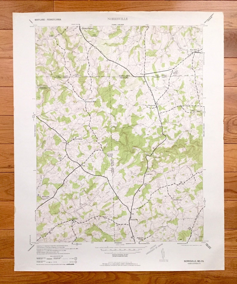
retailer Beautiful, antique map of Norrisville, Maryland and surrounding Harford County and Baltimore County areas, including Pennsylvania's York County. This is an authentic 1953 edition, 1953 print from the U.S. Geological Survey and NOT a computer reproduction.
See what Maryland and Pennsylvania looked like over 65 years ago. Lots of intricate details and geological contours. Map even has little squares for every house that existed at the time. The USGS cartographers were very thorough back then!
Perfect for the historian, map-lover, the curious or just as a conversation starter. Wonderful and rare. Vintage maps such as these make great gifts.
Edition of 1953, printed 1953
Dimensions: 22" width x 27" height
----
Features
Cities & Towns: MARYLAND: Gorsuch Mills, West Liberty, Shane, West Liberty, Stablersville, Vernon, Amos Mill, Ivory Mill, Drybranch, Shawsville, Trump, Carea, Fords, Bradenbaugh, Gemmills.
PENNSYLVANIA: Stewartstown, Shrewsbury, Wiley, Fawn, New Park.
Points of Interest: Deer Creek, Ebaughs Creek, Leibs Creek, South Branch Muddy Creek, Harris Mill Creek, Second Mine Branch, First Mine Branch, Little Deer Creek, Jackson Branch, Island Branch, and many more hills, streams, ponds, houses, schools, railroads, churches and roads.
Condition: Good Vintage condition, commensurate with age. This map is in great shape for being over 65 years old. Has some edge-wear but will read as character when framed.
----
We will happily adjust shipping price for multiple purchases. Maps are rolled up and shipped in sturdy mailing tubes, never folded.
Antique Norrisville, Maryland 1957 US Geological Survey Topographic Map – Harford, Baltimore County, MD, York County, retailer Stewartstown, Wiley PA
- Antique Norrisville, Maryland 1957 US Geological Survey Topographic Map – Harford, Baltimore County, MD, York County, Stewartstown, Wiley PA
- Rc Car Mamba Monster Esc And Tacon Brushless 1/10 Scale Motor TESTED
- Iphone XS MAX 64 GB . ( Unlocked For Any Carrier)
- Gucci watch men
- Dior Homme Parfum
- Superplastic janky custom blue gloomy
- Fisher Price City
- Gold Charizard Celebrations Ultra Premium Collection
- Matilda Jane moonlight magic sleeping bag
- Vintage Polaroid OneStep Plus Camera